
Reinsurance brokers warn of potentially significant impacts from hurricane Milton
- August 16, 2025
- Posted by: Luke Gallin
- Category: Insurance
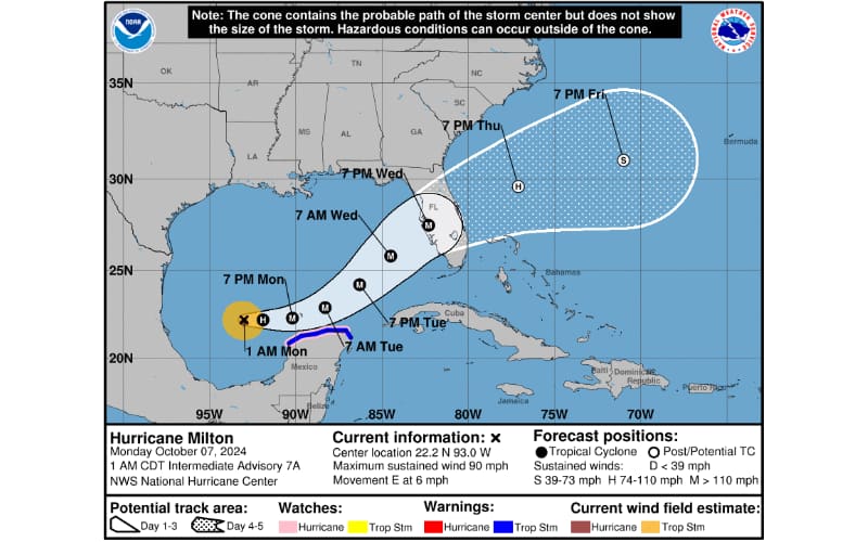
With maximum sustained winds of 90 mph, Milton is likely to become a major hurricane later today and is moving “erratically eastward” through the southern Gulf of Mexico, according to the National Hurricane Center (NHC), and reinsurance brokers Guy Carpenter and Howden Re have warned of potentially significant impacts from the storm as it heads towards the Florida coast.
The latest update from the NHC forecasts that Milton, currently a Category 1 hurricane, will rapidly intensify and reach Cat 3 or higher strength later today as it tracks just north of the Yucatan Peninsula and across the southern Gulf of Mexico, expected to approach the west coast of the Florida Peninsula by Wednesday.
In terms of landfall, the greatest consensus points to a direct hit to Tampa Bay as a Cat 3 storm, but there remains widespread uncertainty and Milton is projected to be a complex and unique storm that is proving difficult to forecast.
“Milton will be passing over warm waters with reduced wind shear, but with an increase in wind shear of unclear timing as it approaches the Florida Gulf Coast,” says Guy Carpenter, the reinsurance broking arm of Marsh McLennan.
“Compared to the high confidence forecast for Hurricane Helene last week, the confidence in Milton is the total opposite,” continues the firm.
There’s uncertainty in both the track and the strength of Milton as it approaches the Florida coastline, with some models taking the storm as high as a Cat 4 of 5 as it moves across the Gulf, but with weakening anticipated prior to landfall.
“The ramifications of the upper end forecasts of Milton would result in a near worst case scenario for the west coast of Florida. There are no historical events that reasonably approximate the projected track of Milton. The five historical events that are closest to the Milton forecast are poor matches: the Cedar Key Hurricane of 1896, Gladys 1968, the October 1921 Tampa Bay Hurricane, Charley 2004, and Ian 2022. The 1921 Tampa Bay Hurricane would be the best fit of these 5,” says Guy Carpenter.
The 1921 storm, commonly known as the Tampa Bay Hurricane of 1921, was a Cat 3 storm at landfall, and brought storm surges of up to 11 feet in parts of the bay, with widespread flooding and extensive damage to buildings, leading to high economic losses.
There’s concern that Milton could lead to significant wind damage and also result in record storm surge for parts of the region, but this will all depend on the strength of the storm as it approaches land, while the location of the landfall is unclear as the forecast cone is still fairly wide, although this will narrow as Milton’s path becomes clearer.
Howden Re’s Anna Neely, Head of Catastrophe R&D at the reinsurance broker, has also commented on the uncertainty surrounding Milton.
“The range of outcomes will generally follow a slower approach and weaker landfall or a faster approach and stronger landfall. Regardless of the wind strength at landfall, Milton is expected to build up a large storm surge that would carry through until landfall,” said Neely.
Justin Roth, Associate Director, Catastrophe Analytics R&D, added: “As Milton is still in the early stages of development, initial forecasts will be subject to change as we gather more data and receive updates. However, there is strong model consensus predicting rapid intensification over the next 48-60 hours. Milton is currently in a favorable environment for rapid intensification as it will move over the ‘Gulf Loop’ – like Helene and other major storms such as Ian, Michael, and Wilma. After 60 hours of strengthening Milton is expected to encounter strong shearing, therefore timing is extremely important with this storm.”
Roth notes the potential for storm surge to reach up to 15 ft in some areas, if Milton maintains its current trajectory and strength.
“Tropical Storm Milton is projected to become a major hurricane and has the potential to make landfall near or around the Tampa Bay area. If Milton tracks directly into Tampa Bay, it could produce storm surges far exceeding those seen in 1921. Milton could produce storm surges of up to 15 feet.
“The combination of Tampa’s geographical vulnerability and its long “hurricane drought” has created significant concern about what a major landfall might mean for the region. As we saw with Helene (2024), cause severe flooding and power outages; a direct hit from a Category 3 or 4 like Milton could be catastrophic.
“Historically, the Florida west coast, particularly in October, is vulnerable to late-season hurricanes, which tend to approach from the southwest and follow paths similar to what we are seeing with Milton. Over 60% of hurricanes that impact Florida’s west coast happen after the climatological peak of the season in mid-September,” said Roth.
Insurers, reinsurers, and insurance-linked securities (ILS) market participants will be watching Milton closely as it moves across the Gulf and towards Florida. Hot on the heels of hurricane Helene, which brought damaging winds and significant flooding, Milton has the potential to drive significant economic and insured losses.
This website states: The content on this site is sourced from the internet. If there is any infringement, please contact us and we will handle it promptly.